|
A Unique Urban Greenway and Stream
Valley Connector for Baltimore
The Gwynns Falls Trail travels through an
environmentally valuable urban greenway park in west
and southwest Baltimore City along the Gwynns Falls
stream valley, a historically and culturally significant
area. The Gwynns Falls greenway is the most complete
system of watershed parks in Baltimore as originally
envisioned by the Olmsted Brothers in their plan for
Greater Baltimore Public Grounds prepared for the
Baltimore Municipal Arts Society in 1904. The greenway
is composed of over 2000 acres of publicly owned parkland
within the Gwynns Falls stream valley and includes one of
the largest woodland parks in the Eastern United
States - Gwynns Falls/Leakin Park.
You must have the free
Adobe Acrobat Reader
installed on your computer to use the above link to the
printable version of the Trail Map. For a professionally
printed version, contact us at
info@gwynnsfallstrail.org
.
The Gwynns Falls Trail is a hiking and biking trail
that begins in Leakin Park and generally follows the
stream to the Middle Branch and Inner Harbor in the
Northwest Branch of the Patapsco River. The entire
15-mile trail system is open to the public. Within
Gwynns Falls/Leakin Park and its 1200 acres, there
are also approximately 20 miles of additional natural
paths wandering up and down the slopes of this
wilderness park that are wonderful for hiking and
unique in an urban setting.
The Gwynns Falls Trail is a continuous recreation
corridor that connects over 30 neighborhoods in west
and southwest Baltimore with parklands, unique urban
environmental features, cultural resources and
historic landmarks. Local residents and visitors are
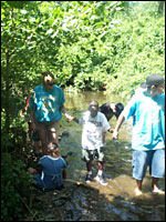
able to bike, hike, roller blade, fish in the stream,
picnic, watch for birds and other wildlife, undertake
environmental education activities, find solitude and
enjoy nature, host community festivals and meet
friends and neighborhood residents along the Trail.
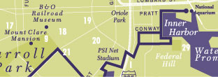
Special Points of Interest and Activities

Some points of interest near or along the currently
improved section of the Trail are the Orianda House
and the Baltimore Chesapeake Bay Outward Bound School
in the Crimea Estate area, the Carrie Murray Nature
Center, Leon Day Park, the historic Carrolton Railroad
Viaduct and Mt. Claire Mansion in Carroll Park, the
B&O Railroad Museum, Middle Branch Park,
Waterview West wildlife observation boardwalk and
deck, the Baltimore Rowing Club, M&T Bank Stadium,
Oriole Park at Camden Yards, Solo Gibbs Park, Federal
Hill Park, and the Inner Harbor West Park and
Promenade. The Trail route offers easy access to
Baltimore's historic cultural heritage, reopening a
carriage path built on an old mill race, ruins of a
mock civil war fort, a relic water wheel, and eighteenth
century plantations and mansions.
The Trail has been the site of several unique and
innovative park events and activities including
National Trails Day, Tour du Park, Hon!, music
concerts, movies in the park, the Leon Day Park
Celebration, Cycle For Life Bike Tour, haunted hikes,
poetry slams, Walk for Wildlife, a prescreening of
Blair Witch: Book of Shadows, annual Art on the Trail
exhibits, and an assortment of festivals, reunions,
and group picnics. A 300-person Ben Cardin picnic
pavilion, amphitheater, and restrooms have been
constructed at the Winans Meadow Trailhead as well
as new facilities provided at Leon Day Park including
a playground, lighted sports fields for baseball,
football, and basketball courts, and restrooms.
Project Partners
Making the Gwynns Falls Trail a reality required a
public-private partnership. Project partners are the
Baltimore City Departments of Recreation & Parks,
Planning, Transportation and Police, the Maryland
Department of Natural Resources, the Trust for
Public Land, the Gwynns Falls Trail Council, the
Parks & People Foundation, and the Citizens of
Baltimore.
The construction and land acquisition funds for the Gwynns
Falls Trail have been provided by the United States and
Maryland Departments of Transportation, Maryland Program
Open Space, the City of Baltimore, and several private
funders. Funding for the Trust for Public Land, the Gwynns
Falls Trail Council and Parks & People Foundation have
been provided by the Wallace Reader's Digest Fund and other
private funders.(
Click for more details about partners and funders.
)
Frequently Asked Questions
How do I get to the Trail?
From the West and I-695 (Baltimore Beltway) to Trailhead T1:
Take I-695 Exit 16, I-70 East/Local Traffic/Park
& Ride. Proceed past I-70 Exit 94, Security
Boulevard, and park in the Park & Ride lot.
The I-70 Trailhead (T1) is at the eastern end of the
Park & Ride.
From the West and I-695 (Baltimore Beltway) to Trailhead T2:
Take I-695 Exit 16, I-70 East/Local Traffic/Park
& Ride. Exit at I-70 Exit 94 to Security
Boulevard. Stay in the right lane and turn right
at the Ingleside Avenue traffic light. Cross the
bridge and turn right at the top of the bridge
(just before the Franklintown sign). Proceed one
block to the stop sign at Franklintown Road and
turn left. Proceed on Franklintown Road approximately
1.5 miles past the intersection with Winans Way,
and the Winans Meadow Trailhead will be around the
bend on the left.
From the East and Downtown Baltimore:
Take US 40 west (Franklin Street and Edmondson Avenue
past Edmondson Village (4.5 miles) Go west on US
40 to Winans Way. Turn right on to Winans Way. Follow
Winans Way to the third stop sign and turn right on
to Franklintown Road. Follow Franklintown Road for
1/3 mile to the Winans Meadow Trailhead (T2).

From North Avenue:
Go west on North Avenue. Cross Hilton Parkway. At
the next intersection turn left onto Morris Road,
turn right onto Franklintown Road. Follow
Franklintown Road for approximately 1 mile to the
Winans Meadow Trailhead (T2). Alternatively, at
Franklintown Road turn left and follow it to the
Leon Day Park Trailhead (T4) on the right.
From Liberty Heights Avenue to Trailhead 3:
Take Hilton Street south to Gwynns Falls Parkway
and turn right (west). Follow Gwynns Falls Parkway
to the intersection with Windsor Mill Road and
turn right. Follow Windsor Mill Road for
approximately 3 blocks to the Windsor Mill Road
Trailhead (T3) on the left.
From Liberty Heights Avenue to Trailhead 4:
Take Garrison Boulevard south, bear left at
Clifton Avenue (Walbrook Junction) and turn right
onto Denison Street. Proceed to North Avenue and
directly across to Morris Road. Follow Morris Road
to Franklintown Road and turn right. Follow
Franklintown Road for approximately 1 mile to the
Winans Meadow Trailhead. Alternatively, at
Franklintown Road turn left and follow it to the
Leon Day Park Trailhead (T4) on the right.
From North Central Baltimore and I-83:
Northbound on I-83 take 28 th Street west bound to
Druid Park Lake Drive. From local roads or I-83
southbound, take 29th Street westbound to Druid
Park Lake Drive (The Druid Hill Reservoir is on the
right). Follow Druid Park Lake Drive to McCullough
Street (Druid Hill Park is on the right). Move to
one of the two left-hand lanes. Continue to Gwynns
Falls Parkway and turn left. Follow Gwynns Falls
Parkway to Hilton Street and turn left. Continue
on Hilton Street to North Avenue and turn right.
Proceed to the next intersection and turn left on
Morris Road. Turn right onto Franklintown Road.
Follow Franklintown Road for approximately 1 mile
to the Winans Meadow Trailhead (T2). Alternatively,
at Franklintown Road turn left and follow it to the
Leon Day Park Trailhead (T4) on the right.
Please Note:
Trailheads (and other locations) have kiosks with
maps showing the Trail and the surrounding area.
Paper maps are available at kiosks as well.
Click the Trailheads below for location maps.
Trailhead 1
– Gwynns Falls Park at Interstate
70/Park & Ride at Security Boulevard/near Franklintown.
Trailhead 2
– Leakin Park at Winans Meadow, 4500
Franklintown Road, Baltimore, MD 21229
Trailhead 3
– Gwynns Falls Park at Windsor Mill Road, 4300 block
Windsor Mill Road, Baltimore, MD 21207
Trailhead 4
– Leon Day Park at Franklintown Road, 1200 block North
Franklintown Road, Baltimore, MD 21216
Trailhead 5
– Gwynns Falls Park at Frederick Avenue, 2700 block
Frederick Avenue, Baltimore, MD 21223
Trailhead 6
– Carroll Park at the Golf Course, 2100 Washington
Boulevard, Baltimore, MD 21230
Trailhead 7
– Inner Harbor at the Baltimore Visitors Center, 401
Light Street, Baltimore, MD 21202
Trailhead 8
– Middle Branch Park at Waterview Avenue, 3301 Waterview
Avenue, Baltimore, MD 21230
Trailhead 9
– Middle Branch Park at Hanover Street, 3200 block South
Hanover Street, Baltimore, MD 21225
How long is the Trail?
The Trail is 15 miles long.
What neighborhoods does it go through?
The Trail will pass by 30 different communities in
West, Southwest and South Baltimore. They range
from Dickeyville, Walbrook, Edmondson Village,
Windsor Hills, Shipley Hill, Pigtown, Morrell Park,
Federal Hill, Otterbein, and Cherry Hill.
What parks does the Trail connect?
Leakin Park, Leon Day Park, Gwynns Falls Park,
Carroll Park and Carroll Park Golf Course, Middle
Branch Park, Solo Gibbs Park, Ridgely's Cove Park,
West Park and Federal Hill Park.
Is the Trail a safe place to be?
Yes, the Baltimore City Police Department
occasionally assigns Police officers to patrol the
Trail which has experienced no serious physical
incidents since beginning operation in 1999. This
is clearly an example of "a used trail being a
safe trail."
Is the surface of the Trail consistent throughout?
No, the surface changes in different areas. Asphalt
is the predominant surface, although 1 mile is
crushed stone, both of which are easy for bikers and
walkers to use.
Can you bike? Can you hike?
Yes, all throughout the Trail and its many
connecting paths.
Who uses the Trail?
Trail users are daily bike commuters, runners
exercising, neighborhood residents (Some who walk
dogs on leashes), students and teachers, business
employees, tourists, and visitors from beyond the
Baltimore area.
Are dogs allowed on the Trail?
Yes, if kept on a leash on all sections of the trail and in
parks.
What will I see while I am on the Trail?
You will see beautiful scenery, historic sites, cityscapes,
bridges and water. Come and explore!
What are some of the benefits of the Trail?
Open space and recreation opportunities affect neighborhood
quality of life, reduce crime rates, and positively shapes
perceptions of the city's attractiveness as a place to live,
work, learn, and play.
The Gwynns Falls Trail offers:
-
More recreational, social and cultural opportunities for
the City of Baltimore
-
Trail and greenways improve property values
-
Safer pedestrian and bicycle access
-
The most dramatic scenery within an urban wilderness
setting
-
Promotes environmental education and outdoor
classroom activities
-
Potential for youth employment opportunities
-
Stronger ties to other communities and institutions
-
Amenities for diverse population
How do I get more information about the Trail?
Contact the Baltimore City Department of Recreation
& Parks at 410-396-7012 or the Parks &
People Foundation at 410-448-5663. Faxes may be
sent to 410-448-5895 to the attention of the Gwynns
Falls Trail Council.
Can outside groups plan and schedule events and activities?
Yes, you can host parties, picnics, and family
reunions on the Trail. There are several picnic
groves and a large picnic pavilion at Winans Meadow
Trail Head, which accommodate up to 300 people, as
well as facilities at Leon Day Park, the Waterview
West Wildlife Boardwalk, and Middle Branch Park,
all available for group activities.
How can I get involved?
You can be one of many who join and take an active
role in the Gwynns Falls Trail Council.
Become a member!
You can also
volunteer
to lead hikes, plant trees, host festivals, and clean
up park areas surrounding the Trail.
Sign up
or
contact us.
|
|
|